


There is a contract and the first excavations. Two pedestrian and bicycle crossings will finally be built in Poznań. Planned completion of the works: the year 2025. The so-called Berdychowskie Bridges will be a functional revolution for the Old Town, Ostrów Tumski and the right bank of Poznan. Construction workers will start work soon, now archaeologists are working.
Heaps of earth and excavations and archaeologists scrambling among them on the southern tip of Ostrów Tumski are the first visible sign of the long-awaited construction, about whose plans we have written more than once. After all, the realization of the pedestrian and bicycle Berdychowskie Bridges (formerly less accurately known as the "footbridge") was announced by the City almost nine years ago, but it was only in June of this year that it signed a contract for the work with Budimex, which is to carry out the investment by the end of 2025. In January, this contractor was selected in another tender (the earlier ones ended in fiasco, due to too large a difference between the assumed budget and the bidders' proposals).

Berdychowskie Bridges in Poznań, visualization, view from the south towards the Cathedral; left: Old Gasworks, right: Politechnika campus
© City of Poznań; design: consortium ARPA Architektoniczna Pracownia Jerzego Gurawskiego, Błażej Szurkowski, Maciej Sokolnicki and Adam Turczyn.
A refined design by a consortium of studios and designers will be implemented: ARPA Architektoniczna Pracownia Jerzy Gurawskiego, Błażej Szurkowski, Maciej Sokolnicki and Adam Turczyn awarded in the 2018 architectural competition.

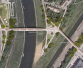
view of the site for the future Berdych Bridges from St. Roch Bridge; left: the Old Town and gasworks, right: the Polytechnic University campus, opposite: the promontory of Ostrów Tumski (the site of ongoing excavations)
photo: Jakub Glaz
the only friendly one
The new crossing will directly connect the Old Town on the left bank of the Warta River, Ostrów Tumski and the Polytechnic University campus on the right bank. The first 165-meter-long bridge will be thrown over the Warta River, precisely between the buildings of the Old Gasworks and the park in the Old Warta Riverbed and the southern part of Ostrów called Zagórz.

A view from the park in the Old Warta Corridor to the site of the bridge over the Warta River
photo: Jakub Głaz
A second, shorter bridge (117 meters) will be built over a short relief canal connecting the Warta River with the Cybina River. It will connect Zagórze with Berdychowo Street, separating the buildings of Poznan University of Technology, and will lead towards the nearby Lake Malta recreational area. After the cycling traffic has been civilized on a short section of Berdychowo, the route will become a convenient and important connection for cyclists going to the center from the Rataje district (which is formally part of the New Town administrative district).

view of the site for the new bridge from Ostrów Tumski; the chimney of the Old Gasworks is visible, the bridge abutment will be built on the left side of the ramp visible in the middle of the photo
photo: Jakub Głaz
This will create a convenient and much-needed route that will bring attractive areas closer together. For many years to come, it will be the only pedestrian- and cyclist-friendly connection between the Old Town and Ostrow Tumski, the cathedral standing on it, other monuments and—further—with the Śródka district. Currently, the only access leads over the Chrobry Bridge, part of a scaled-down traffic route that cut through the city in the 1960s. The narrow sidewalk, noise, exhaust fumes and collision of pedestrian traffic with cyclists are extremely unpleasant here (cyclists should take the roadway, but this risks being rammed by cars whose drivers have no regard for speed limits).

The area of the Old Gasworks as seen from above the wall at the level of the new crossing abutment; eventually (date unknown) this area is to be functionally connected with the park in the Old Warta riverbed, Wartostrada and new bridges
photo: Jakub Głaz
longer and without frankenstein
The route across one of the new bridges will be slightly longer, but much more pleasant and safer. Only residents of terraced houses from the 1960s in Zagorz are reluctant to see this connection. The previously secluded enclave will be bordered by the abutments of the two bridges and the space between them enriched with rest areas and small architecture.

An enclave of terraced houses from the 1960s in Zagórze, Poznań
photo: Jakub Głaz
It is within this area that archaeologists are currently working, hoping to discover at least relics of 19th century fortifications (in the area of the promontory stood a sizable Reduta (fort) Radziwiłł dismantled in the early 1950s. There is also a rather slim chance of finding traces of an earlier settlement, from the time when pre-local Poznań developed right here (until 1253). One can only hope that archaeologists will act faster and more efficiently than they did a few years ago, during the excavations within the Kolegiacki Square, which were prolonged beyond measure.

The southern tip of Ostrów Tumski, right bank of the Warta River; visible excavations at the site of the future bridge abutment
photo: Jakub Głaz
Finally, last but not least, Poznań will gain an elegant, non-glamorous element of the downtown landscape. Structures of light form without additional supports in the current and floodplain will blend discreetly into the silhouettes of the Old Town and Ostrów Tumski.

one of the Berdychowski Bridges
© City of Poznań; design: consortium ARPA Architektoniczna Pracownia Jerzego Gurawskiego, Błażej Szurkowski, Maciej Sokolnicki and Adam Turczyn
However, it was close, and the crossing would have been a bridge Frankenstein—a clumsy conglomeration of old truss spans of a railroad bridge in the south of Poznań (between Starołęka and Dębina). Such „recycling” was advocated eight years ago by the city's historic preservation officer. After protests from the architectural community and social activists, the city authorities abandoned the unfortunate intention and held a competition. There is finally a real chance that its result will become flesh.
separation necessary!
Budimex is now developing the final technical documentation. Perhaps, at this final stage, it will be possible to separate pedestrian and bicycle traffic in the design of the bridges. Such a necessity has long been pointed out by activists and specialists from the Bicycle Poznań association, expecting very heavy cyclist traffic on the crossing. For now, they have succeeded in the near vicinity. For a month now, an important road called the Cycling Salt Route has finally been built along the dangerous thoroughfare already mentioned here with the Chrobry Bridge.

Construction of a new bicycle road along the traffic route in the course of Estkowskiego, Małe Garbary, Wolnica, Solna streets; the eastern end of the route, just beyond the Chrobrego Bridge
photo: Jakub Głaz
The new section begins, unfortunately, already behind the bridge, on the western side (the current width of the bridge does not allow to mark out bicycle lanes). It will continue along the northern edge of the Old Town to Kulasa Street, which is the western part of the bicycle ring road of the downtown. Planned end of the work: roughly in six months.


