


In 2018, designers from Warsaw-based studio OPEN architects were commissioned by the government of Tanganyika, a new province in the Democratic Republic of Congo, to design a development study of the area's capital, the city of Kalemie. The work was completed this year.
The aspirations of the authorities vs. the needs of the residents
Founded in 1891, the city was called Albertville and was located about fifteen kilometers south of the current location of Kalemie, on the western shore of Lake Tanganyika, the world's longest freshwater lake, which, during the colonial conquests of this part of the continent, formed a natural boundary of European and Arab influence. The city was founded by Captain Alphonse Jacques, a member of the Belgian Anti-Slavery Society.


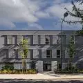
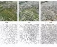
left: view from the hills, right: houses of displaced persons
© OPEN architects
The town was erected again a few years later on the site of the village of M'Toaw. The decision to locate there was influenced by its convenient location: the relatively flat coastline at the foot of gentle hills, right at the mouth of the river, provided a suitable site for the construction of a port, connecting the areas annexed by the Belgians with those of today's Tanzania and Burundi. A railroad was brought to the city in 1915, and the strategically located port became a naval base for the Entente and Allied navies during the subsequent world wars.
The city was organized along the coastline. The focal points were the port and the railroad station, and the main artery connected the hill with the Cathedral of the Holy Cross in the south to the bridge over the Lukuga River, on whose flat northern bank industry was located. Closer to the center, Belgian administrators lived on the green hills, while the local population lived inland.
After the country's independence, the city developed dynamically but haphazardly (the last planning study was the 1955 zoning plan) becoming, among other things, a refuge for internally displaced persons seeking relief from the ongoing tribal fighting between the Batwa Pygmies and the Luba people since 2013. Nominally, the city currently has a population of about 100,000, but provincial authorities estimate that there are actually about 500,000, most of whom are just displaced persons. Some of the displaced have been deployed in camps located both inside the city and in its suburbs, while the more affluent have chosen to become residents.

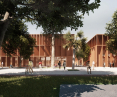
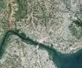
Kalemie today
© OPEN architects
The study, as its authors emphasize, was intended to respond to the aspirations of the authorities (the dream of a metropolis, backed by various inspirations from the world, not necessarily in harmony climatically or culturally) and to the needs of the local community related to the uneasy living conditions.
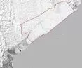
The architects, working on archival documents and making site visits, recognized the area's environmental problems, such as the piling up of the lake's waters at the height of the city, resulting in the shoreline moving inland and more houses and streets being swallowed up by the water.

lake absorbs more buildings
© OPEN architects
In analyzing this problem, we noted that this process is inextricably linked to the dynamic growth of the city, whose new residents are spontaneously settling the hills located on the southern bank of the Lukugi River. The urbanization of the hills consists primarily of clearing vegetation and leveling the land for houses and home gardens. This procedure results in the uncovering of the land, the elimination of retention potential, and the consequent washing out of the huge land masses that flow into the lake. The mud is sucked up by the Lukuga, causing blockages that prevent the lake from draining properly. The result is a piling up of the water table at the river's mouth , the project's authors write.
socio-economic structure
An important part of the local economy is fishing and the distribution of copper, tin, cobalt, zinc and coal mined in the province. However, most of Kalemie's residents rely on agriculture for their livelihoods and live mainly in the hills and areas on the north side of the river. Some of them grow crops only for their own use in home gardens, while others cultivate plots of land located outside the urban fabric. The clerical staff and owners of companies operating in the city live in the areas closest to the shore of the lake, formerly intended for Belgian administrators.
Children and young people make up a significant portion of the city's population. Although primary education here became free in 2019, enabling many families to send their children to school, the city still lacks school centers. It is worth mentioning, however, that there is a university in Kalemie.