


Students of the Faculty of Architecture at the Silesian University of Technology, as part of their course in Urban Design—Structure of the City under the direction of Dr. Tomasz Bradecki, have prepared a comprehensive publication „Models of the structure of the GZM Metropolis”. And what can you find in it? An analysis of the functional and spatial structure of the Upper Silesian-Zagłębie Metropolis in augmented reality, 3D models and possible scenarios for its development. The publication in Polish and English is intended to help you understand what the Metropolis is and its structure and potential.
The publication „Models of the structure of the GZM Metropolis,” which is available for download online in its entirety, was produced under the editorship of a team composed of Tomasz Bradecki, PhD (originator and initiator of the entire series), Jakub Ludwig, Błażej Mól, and Krzysztof Kafka, PhD.
This is the third publication in the series devoted to models of city structure. The initiative was launched as part of a teaching class in 2018. So far, general analyses of the cities of the Upper Silesian Metropolitan Union (2018), Bologna (2019), Aachen (2020), and detailed studies on Zabrze (2021) and Gliwice (2022) have been carried out in this format.

"Models of the structure of the GZM Metropolitan Union," team of authors.
© Department of Architecture, Silesian University of Technology
The author's method used in the series uses data on cities, which are presented in the form of 3D spatial models using augmented reality technology, as well as physical models.
© Department of Architecture, Silesian University of Technology
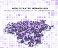
analysis of GZM
The purpose of the publication is to present, analyze and synthesize data on the Upper Silesian-Zagłębie Metropolis. In order to make it possible to compare the relationship between the various elements that make up the metropolis, the authors used a cellular model of the kilometer grid and the boundaries of the districts of each metropolitan municipality. The result is a synthetic picture of a metropolis composed of dozens of districts. The research group, in order to compare the properties of the districts, worked in the PBL (Project Based Learning) formula using GIS software, 3D models, augmented reality models, and artificial intelligence.

Presentation of the publication „Models of the structure of the GZM Metropolis”.
© Faculty of Architecture, Silesian University of Technology
This is what Prof. Alessandro Camiz of Ozyegin University in Turkey wrote about the publication:
The purpose of the publication, both in English and Polish, is to clearly share with the broader community, not only locally, but also internationally, the advanced tools adopted to analyze and represent the Upper Silesian-Zagłębi Metropolis. In addition, it is worth adding a few words about the GZM area, which, presented, seems to introduce an innovative settlement model, populated with innovative buildings and urban structure. Perhaps this dispersed metropolitan organism is proposed as an important alternative to the compact city, in the form of a landscape city (citta'paesaggio).
Prof. Mateusz Gyurkovich of the Cracow University of Technology also commented positively on the publication
[...] Appropriate, contemporary research methods were adopted (including the use of QGIS and AI), the set goals were achieved, and moreover, they were presented in the publication submitted for review in an innovative manner [...]. The presented results of research and simulations—the title „models” of GZM development—are very interesting and show the research and design maturity of the authors. The publication presented for evaluation is a full-fledged scientific position, another voice in the discussion of the future of Polish urbanized space.

model manual and QR code listing
© Department of Architecture, Silesian University of Technology
The second particularly interesting content concerns the definition of the minimum unit of reference, referred to in this publication as „neighborhoods.” Any modeling of such a complex phenomenon as a city requires a certain level of abstraction to reduce the analyzed variables to a finite computable number. The analysis of an urban phenomenon as vast as the GZM metropolitan area requires the division of the whole into parts, that is, the application of a Cartesian treatise on method: the division of a complex problem into many simple problems— Prof. Lamberto Amistadi of the University of Bologna.


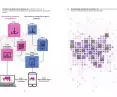
Functional decomposition dependence analysis and GZM analysis model based on Kevin Lynch's method
© Faculty of Architecture, Silesian University of Technology
what is a metropolis?
The publication, together with the models, helps to understand what a metropolis is , its structure and potential. The studies using GIS and current CSO data are worth noting. A synthetic model of a 15-minute metropolis illustrates the accessibility of various remote districts. Interesting is the blue-green infrastructure model, which shows how much green, potential the metropolis has. Analysis of the metropolis based on Kevin Lynch's theory, which is classically used to interpret cities, was also realized. The author's team also developed possible scenarios for the development of the metropolis (positive and negative).

attempts to use artificial intelligence to create images of the future
© Department of Architecture, Silesian University of Technology
The accompanying graphical studies could be considered abstract, but they systematize the knowledge of the data and demonstrate the diversity of the metropolitan structure graphically and spatially. This provides an opportunity to experience and understand the metropolis as a whole. The creative use of spatial data in GIS and its visualization is a challenge that combines the fields of planning, urban planning, architecture, as well as art. The models that have been made in the development of the data should be considered experimental [...]. The models presented are in fact graphical presentations of the results from the analyses. The first important conclusion is the demonstration of the high degree of differentiation of the entire metropolis. The models indicate huge disparities in demographic, urban, environmental and spatial indicators. These disparities are primarily between the core of the metropolis and its outer areas. However, the analyses also showed a high degree of disparity between the cities of the core itself, and even between individual neighborhoods or even smaller areas within a single city or municipality. These conclusions confirmed the validity of initially adopting a reference orthogonal grid that isolates individual „pixels” of data. They also confirmed the validity of the thesis of the district metropolis concept. The concept of the GMC as interconnected neighborhoods should be considered a milestone of this study. In the study, the starting point for determining the districts was the extent of the administrative auxiliary units. In further steps, measurements were made to determine whether these districts could be considered as a basis for building a city or 15-minute district system. This illustrates the potential of the metropolis, which can still be explored and developed. The blue-green infrastructure model contradicts the stereotypical image of Silesia as an area exclusively associated with industry. Experiments in creating scenarios for the future of the metropolis can be considered visually appealing, but incomplete. Attempts to use artificial intelligence to create images of the future have been successful for specific locations, while they have not yielded the right results on the scale of a municipality or an entire metropolis, conclude Tomasz Bradecki, PhD, and Krzysztof Kafka, PhD.
All the developed models can be viewed at the following addresses (just click on the name):
- population growth and loss,
- population density model,
- building area share model,
- functional-spatial model,
- total road length model,
- public transportation pattern model,
- model of the number of cars on the kilometer grid,
- blue-green infrastructure model,
- 15-minute metropolis model,
- proportion of development in urbanized areas,
- analytical model,
- model of metropolis development directions,
- functional and spatial structure model.