


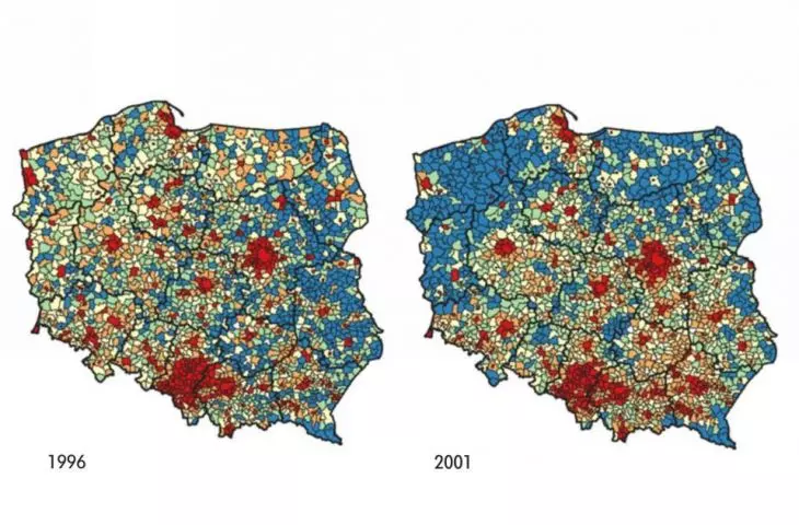
Big cities are growing, smaller ones are shrinking. Some are beginning to resemble bagels. These are the conclusions of researchers who are checking with a new method the growth of Polish agglomerations and their suburbanization. Even information on nighttime lighting obtained from satellite is proving useful.
That Polish cities are spilling over in an uncontrolled manner has been known for about two decades. The boundaries between large urban centers and the wider countryside are blurring, and it is becoming increasingly difficult to monitor a space that is turning into an amorphous translation of functions. The flow of data on the intentions and development of neighboring cities and municipalities is also poor. The scale and dynamics of urban sprawl are therefore not well documented and realized, and this makes it difficult for local governments to react quickly enough.
An interesting and, as the press materials argue, "nationally innovative" method of determining the boundaries of cities (or rather, agglomerations) has recently been presented by an interdisciplinary team that includes researchers in economics, data analysis, statistics and the study of urbanization processes. It is made up of Dr. Olha Zadorozhna (Leon Kozminski Academy), Dr. Bogna Gawronska-Nowak ( Institute for Urban and Regional Development) and Dr. Piotr Lis (Coventry University). The project they have prepared is called "A new model of urbanization in Poland - practical implementation of the principles of responsible urbanization and the compact city."
light faster
What is the novelty supposed to consist in? The method uses data from satellites depicting nighttime lighting of roads and buildings, and then combines it with information on population density, commuting time, the number of businesses and apartments per thousand people, among others. This approach makes it possible to more precisely delineate the boundaries of sprawling agglomerations and assess the effects of suburbanization. According to Dr. Olha Zadorozhna, the use of data on the lighting of roads, homes or businesses makes it possible to spot newly emerging businesses or neighborhoods better and faster than traditional data.
The researchers' analysis shows the transformations that Polish cities have undergone in the last two decades and confirms intuitive or scattered conclusions already formulated on the subject: large cities are growing and smaller ones are shrinking. An obvious example is Warsaw, Wroclaw or Krakow. The Łódź and Poznań agglomerations, for example, are also crumbling, although in a specific way. Mass growth in municipalities neighboring the main center is accompanied by shrinking centers, which may bring to mind a bagel.
The middle class is moving out from under the city, so that the municipalities surrounding the large centers record much higher per capita income than those farther away. The same is also happening in smaller cities, such as Kielce and Radom. Zadorozhna notes that the larger the city, the more strongly the population density of its closest neighborhoods and towns increases. However, the real boundaries of smaller centers have shrunk, among them the cities of Upper Silesia or Walbrzych.
better on your own
The study itself and its results seem interesting, but how can this method support practical action? The researchers report that "the study is intended to help local governments and government institutions learn how to minimize the negative effects of sub- and de-urbanization processes." Especially since the method examines "spatial and economic-social linkages between municipalities."
Sounds good, but supra-municipal planning does not exist in practice. Instead, the planning process is characterized by considerable inertia, which does not allow it to react to rapidly changing realities.
With our method, the ministry can study the situation once every few years, and local governments will be able to use these findings," Olha Zadorozhnaya explains to us, reminding us that the project partner is the Ministry of Development, Labor and Technology (now: Ministry of Development and Technology).
However, the analysis performed every few years may not keep up with the rapidly changing situation, which is especially evident now, during the housing boom.
If it were local governments that wanted to monitor the situation on their own, on an ongoing basis, using our method, they would have to form a small team of people to create such analyses. A plus here would be direct knowledge of local residents' needs, which could be included in the survey, Zadorozhna concludes.
The detailed result of the study can be found in Chapters 4, 5 and 8 of the monograph titled. "How to define the boundaries of urban functional areas? Social and economic gains and losses of urbanization processes in Poland".


