


The case study appeared in A&B 2'2021
In recent years, the design world has been undergoing a major shift. Technology companies have joined the ranks of urban design thinkers. No longer just as providers of design tools and software. What Ben van Berkel (founder of UNStudio and UNSense) predicted is happening before our eyes - architecture is starting to catch up with other areas of our lives in terms of technological development.
Tech giants like Google and Microsoft are taking an interest in the vast amount of data that can be collected in human-occupied spaces. It has been noted that the same tools that help identify user preferences on the Internet can be applied to design. The use of complex computer analytics in the design process, the planning of entire building life cycles and the collection of data during the use of a building will increase the quality of spaces and the comfort of residents and workers.
Major Western architectural firms (e.g., Foster + Partners, Bjarke Ingels Group, UNStudio) are setting up analytical departments and subsidiaries that employ sustainability specialists, programmers, psychologists or big data engineers in addition to designers. Most architecture firms can't afford separate analytical departments, so they have to rely on outside entities capable of providing simulations to make similar attempts.
In June 2020, a consortium of Arup Poland, Roark Studio and Designbotic entered an architectural competition for a residential and office development complex organized by Allcon Osiedla in Gdynia (the best project turned out to be that of Grupa 5 Architekci studio).

year-round analysis of insolation of public and semi-public spaces
© Designbotic
The design team of the aforementioned consortium included architects, constructors, geotechnical engineers, sanitary, electrical, teletechnical designers, as well as specialists in sustainable development and architectural simulations. An attempt was made to introduce computer analyses of solar insolation, solar gains, shading of neighboring buildings, and tunnel analyses of wind impacts on buildings and urban interiors at the initial design stage. The simulations were repeated several times, and their results influenced design decisions, which the team believes was important for the final outcome. The designed layout of the development was, by design, to include a high-rise building, so the issues of wind impact or shading on neighboring buildings were extremely important.
Such a mode of work was, in a sense, an organizational experiment; the idea was to see how the working methodology taken from the most technologically developed teams would work out in practice.
architectural simulations
and their impact on design decisions
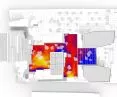
The basic analysis performed for each concept, was to check whether the insolation conditions for the proposed residential development and the neighboring development were met. Working with the Building Information Modelling methodology, the search for possible solutions was carried out from the very beginning on the three-dimensional models used in the simulations. Insolation analysis was performed using computer simulation, which calculated the number of hours of direct sunlight for the facade of the designed building and the neighboring building with an accuracy of 0.5 square meters. The process itself, thanks to the preparation of data exchange methods prior to the start of the project, was able to be reduced to 7-10 day iterations for subsequent preliminary concepts. The simulation was also used to calculate direct sunlight hours for public and semi-public spaces. By providing additional information on the impact of building masses on the number of hours of sunlight in a space throughout the year, it was possible to introduce an additional criterion for evaluating solutions.

Comparison of sunshine duration simulation results for two early residential development concepts
© Designbotic
Other daylight-related analyses were the Daylight Factor (DF) and Spatial Daylight Autonomy (sDA) analyses required to meet criteria related to light availability (BREEAM, WELL) for office spaces, and therefore to provide employees with appropriate conditions related to visual comfort. The designed residential and office developments in each concept were analyzed in parallel in terms of their mutual impact on lighting conditions. In the case of the office section, simulations were performed for the building's interior. During the first iterations, compliance with the conditions specified in the certification schemes was analyzed both in terms of meeting the minimum coefficients and minimizing the space exposed to unfavorable conditions due to excessively intense sunlight. The above simulations required preliminary decisions on the materials used and the form of the facade. For this reason, they were performed each time both the mass of the building and the façade solutions were changed, allowing continuous verification of the fulfillment of the best conditions for building users.

Spatial Daylight Autonomy analysis of office space
© Designbotic
Daylightanalyses are the largest group of simulations, affecting both the form of buildings, public spaces and building interiors. The form of the office building's facade was heavily influenced by solar radiation simulations, which were performed for the entire designed complex to maximize passive energy gains. By using high accuracy analysis (10 cm²) for selected sections of the facade, it made it possible to select solutions that, thanks to their geometry, passively reduced the possibility of overheating during working hours. After the simulations, it was decided to use horizontal razor blades on the southern elevations, and vertical ones on the eastern and western elevations, additionally creating a characteristic layout of the elevations, on the fragments oblique to the directions of the world.

Simulation of energy gains from solar radiation
© Designbotic
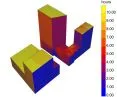
For projects of this scale, it is worth noting their impact on the movement of air masses. Large areas and small distances between buildings, can lead to the creation of both places exposed to strong, sudden gusts of wind, as well as spaces that will continuously stimulate the flow of wind, causing discomfort to users and even endangering their health or life. During the project, CFD (Computational Fluid Dynamics) analyses were carried out three times, simulating a wind tunnel in a virtual environment. Performing the relevant calculations required a solid model of the environment within a 500-meter radius, the terrain relief and weather data on wind speed measurements provided by weather stations. In each case, calculations were made for the four dominant wind directions, while the results provided information on the impact of the designed development on the movement of air masses: they allowed the elimination of potential hazards, increased the comfort of users and influenced the design of landscaping.


result of wind tunnel simulation of air mass movement for the designed space
© Designbotic
The design used commercially available tools, but a new need arose during the work. Due to the location of the plot and the height of the residential dominant (120 m), additional value for the residential units was access to the view of the Bay of Gdansk. Following the decision related to the location of the office building on the eastern part of the plot and in response to the limitation of the residents' visibility to the sea, it was decided to create a customized tool. Using a model of the city and the designed buildings with separate residential units, the program analyzed them for visibility. Using the tool and making changes to the geometry of the office buildings, a solution was found that maximized the number of apartments with a view of the Gdansk Bay. Thanks to the ongoing cooperation between the companies, it was possible to jointly develop and apply a customized tool and visibility assessment method that influenced the architects' decision-making process.


project visualization
© Roark Studio
team's conclusions
In the initial phase of the competition concept work, the need to iteratively work on the solid composition dictated by the results of the analysis was difficult and unintuitive for the architects. Usually, decisions to continue the concept are made on the basis of other parameters, which in the described case also had to be taken into account (fulfillment of the functional program, compliance with regulations, visual attractiveness of the concept, etc.). However, quite quickly the team realized that the additional layer of information resulting from the use of simulations makes it possible to make the right decisions at the initial design stages. This reduces the amount of time spent working on the project - the designers learn about the flaws in the solutions very quickly, which allows them to correct them and focus on other important elements of the project.
Kacper RADZISZEWSKI, Jakub BLADOWSKI
Illustrations: designbotic.pl


