









Municipalities have until the end of today to adopt their general plans. One might therefore be tempted to say that we are in the final stretch of the spatial planning reform. However, this is not the case, and many Polish local governments still have a long way to go. How many Polish municipalities have adopted their general plans on time?
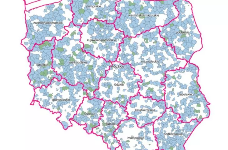
According to data from the National Geoportal, as of August 31, 2026, 792 municipalities had adopted General Plans, which amounts to just under 32% of all municipalities in Poland (there are 2,497 in total). This means that the milestone set by the National Recovery Plan has been achieved: in order for municipalities to receive funding to cover the costs of developing General Plans, the General Plans had to be adopted in more than 30% of municipalities, or 749 municipalities. The National Geoportal is a commercial service that does not present official data—the statistics have yet to be confirmed by the national administration; however, it can be assumed that the minimum required by the National Recovery Plan has been met, and local governments that met the deadline will not have to cover the costs of complying with the planning reform on their own.
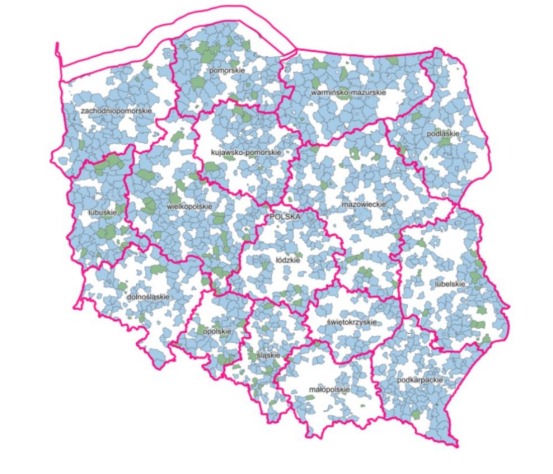
Map showing the coverage of Poland’s territory by adopted and proposed general plans
© screenshot from the website https://www.geoportal.gov.pl/
Which cities already have a general plan?
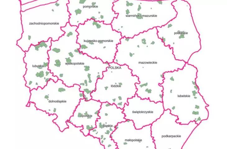
Poland has 18 provincial capitals—which of them adopted a general plan on time? The first major city to do so was Poznań, which adopted its General Municipal Plan on December 18, 2025. For some time now, Opole, Zielona Góra, Olsztyn, Szczecin, Toruń, Gorzów Wielkopolski , and Białystok have also had general plans , and a few days ago , general plans were adopted in Bydgoszcz, Lublin, and Wrocław. There are slightly fewer provincial capitals that are at a more or less advanced stage of developing their General Municipal Plans. Draft General Plans have already been presented by Łódź, Warsaw, Katowice, Gdańsk, and Kielce. The only provincial capitals in Poland that have not yet even presented a draft general plan are Rzeszów and Kraków.
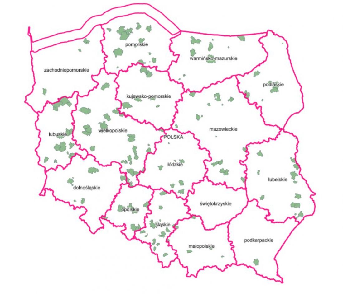
Map showing the coverage of Poland’s territory by adopted general plans
© screenshot from the website https://www.geoportal.gov.pl/
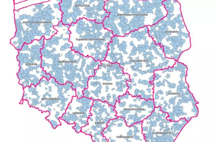
Most provincial capitals in Poland have thus succeeded in adopting General Plans. However, the nationwide statistics offer little cause for celebration, as as many as 68% of municipalities in Poland will have to face the consequences of delays in adopting General Plans. That’s not all—nearly 5% of municipalities haven’t even begun work on their General Plans. What will change for their residents starting September 1, 2026?
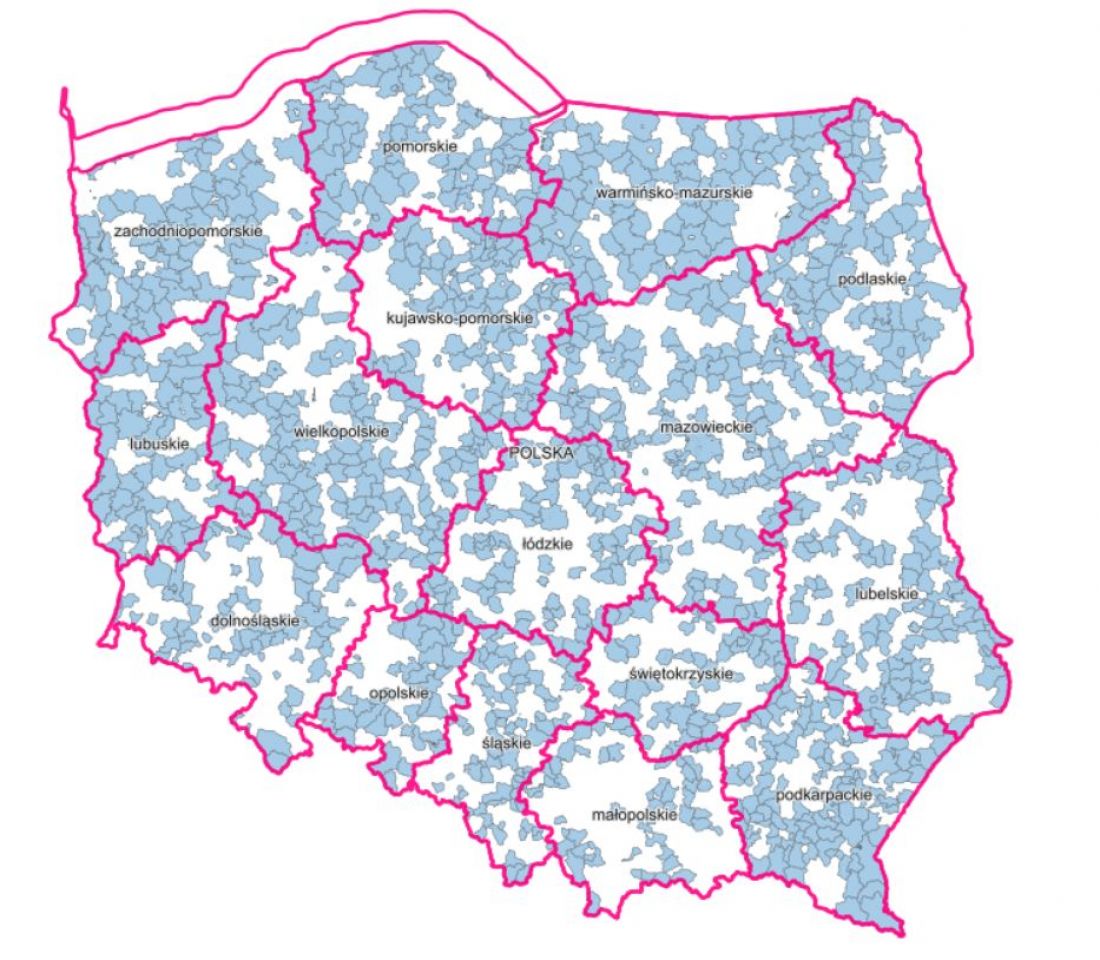
Map showing the coverage of Poland’s territory by proposed General Plans
© screenshot from the website https://www.geoportal.gov.pl/
A Planning Setback—Zoning Decisions After September 1, 2026
Today, a Building Permit can be obtained in two ways, depending on the planning regulations in effect for a given plot of land. If a Local Spatial Development Plan (MPZP) is in effect for the area where a new building is to be constructed, whether a Building Permit is granted depends on the project’s compliance with the plan’s provisions. Otherwise, if a local zoning plan has not yet been adopted for the plot, it is first necessary to establish the development conditions, commonly referred to as WZ or “wuzetka.”
Starting September 1, 2026, in municipalities where a General Plan has not been adopted, a building permit will only be granted for areas covered by a Local Spatial Development Plan. For areas not covered by a Local Spatial Development Plan (MPZP), local governments will cease issuing “wuzetki” until a General Municipal Plan is adopted. There is, however, an exception to this rule—if an application to establish development conditions was submitted before August 31, 2026, the procedure will follow the old rules.
This loophole is the reason for the paralysis of many local governments, which, in addition to working on general plans, must handle the massive influx of applications for the determination of development conditions. Although the estimated time for determining development conditions is approximately 30 business days, in reality, applicants in many municipalities must currently prepare for a wait of several months.
Furthermore, even if the municipality’s General Plan, published after the submission of an application for development conditions for a given lot, calls for a completely different building to be constructed on that lot, the development conditions application will still take “precedence.” Such a situation could arise, for example, at 1 Chorzowska Street in Katowice. The General Plan calls for buildings at this location to reach a maximum height of 40 meters. However, the developer submitted an application for zoning conditions on December 18, 2025, so if the decision is approved, they will be able to build a skyscraper over 130 meters tall in a location where the draft General Plan of Katowice calls for a building no taller than 40 meters.
Due to the planning reform, the changes also affect the development consent decisions themselves. Starting January 1, 2026, decisions establishing development conditions will be valid for only five years from the date they become final. Even more will change once the general plans are adopted. In addition to the previous conditions,a “wuzetka” will only be able to be issued for areas designated in the general plan as “areas for infill development” (OUZ). This reform of the rules governing development permit decisions aims to prevent the phenomenon of de-urbanization, or urban sprawl.

Nearly 70% of Polish municipalities have still not adopted a general plan
Photo: Ron Iach ©pexels
General Plans — Pros and Cons
The spatial planning reform took effect in September 2023. Under its provisions, all municipalities in Poland are required to prepare, by a specified deadline, a new planning document—the so-called General Municipal Plan—which is intended to replace the outdated Study of Conditions and Directions for Municipal Spatial Development. Unlike the Study, which is merely a conceptual document intended to facilitate and structure urban planning, the General Municipal Plan (POG) is a local law; therefore, once it is adopted, all new Local Spatial Development Plans (MPZP), Zoning Decisions (WZ), and the resulting Building Permits must comply with the provisions contained in the General Plan.
It is worth noting that, according to data from the OnGeo.pl database, the coverage of Local Spatial Development Plans (MPZP) for Poland is only 32.6%. General Plans will therefore ensure that, ultimately, planning provisions in the form of local legislation will apply to the entire territory of Poland, even if Local Spatial Development Plans have not yet been adopted for specific areas. Municipal General Plans are thus intended to ultimately organize spatial planning throughout the country, filling in the “gaps” in areas without a binding Local Spatial Development Plan.
An important element of the planning reform is its digital dimension — general plans are created using standardized software, and a so-called “urban planning registry” is to be established, which will significantly simplify navigation through individual land-use documents.
However, errors were not avoided during the digitization process:
In the medium-term development strategy, we stated that we must digitize the entire spatial planning process. However, the digitization driving the reform does not improve urban planning practices ; what can be included in land-use planning documents is determined by what is optimal from the perspective of digital tools. An integrated approach—that is, the overlapping of various issues in digital documents—is difficult to achieve, which is why the government has abandoned it.
— says Tomasz Majda, president of the Association of Polish Urban Planners, in an interview with A&B.
Municipal General Plans also face other challenges. As the name suggests, General Plans are characterized by a high degree of generality, which is not always viewed positively. Furthermore, a municipality’s General Plan is subordinate to another document—the Municipal Development Strategy—which, in essence, is not a spatial planning tool but rather a document outlining directions for spatial, as well as economic and social, development:
[...] The European Council of Town Planners has stated in its documents that space should serve as the framework for optimizing all sectoral policies. Meanwhile, the National Spatial Development Plan (KPO)—against which the Association of Polish Urban Planners has protested from the very beginning—stipulates that spatial planning will be integrated into development policies, while policies for climate change mitigation and adaptation will be formulated under a completely different framework — functions such as water and forests have been removed from the general plans. Added to this is the entire cultural dimension, which has virtually disappeared from the general plans, along with public space, which is the vehicle for our European values. There are also no planned roads—although we should be in line with the provincial plans, which outline the target road and rail networks, the general plan cannot designate something that is still only in the planning stages. So, in reality, these aren’t plans at all!
— explains Tomasz Majda.
Although one of the intended effects of the planning reform is to reduce the fragmenting impact of zoning regulations on spatial management, the general plans themselves also suffer from shortcomings in this regard:
[...] A characteristic of Polish spatial planning is that we think either on a micro or macro scale. A study or a general plan is a document of a very high level of generality. In theory, a general plan addresses individual parcels, but very often these do not form a coherent whole or a vision for a larger area. However, this way of thinking is not the role of a general plan; its task is to record in the urban planning registry the parameters of a given plot—in terms of intensity, height, percentage of built-up area, and so on. Only then do we have either a local plan or a ZPI, which—as is often the case—are created for a single plot. Consequently, the relationship between the two is practically nonexistent. What is needed, therefore, is a vision for shaping the larger whole.
— explained Prof. Piotr Lorens, City Architect of Gdańsk, in a conversation with Ola Kloc.
However, not everyone agrees with the negative assessment of the General Plans. Among those who hold a different opinion from a significant portion of the professional community is Łukasz Pancewicz, an urban planner at A2P2 architecture & planning:
General plans will allow us to streamline the old studies, which were not very effective tools for steering the city’s development. For a large local government, preparing a study meant several years of hard work, and the document itself combined a vast list of constraints with a meager layer of information regarding the management of the municipality’s development, blending spatial planning with toothless attempts at development management. The idea that a strategic document containing a spatial component [general plan—ed.] should guide urban development is also very wise. It finally equips spatial planning with development tools. This is a positive step in the reform that still lies ahead of us. Municipalities will begin updating their strategies, and this is rarely discussed. I think urban planners do not fully understand how important this element is.
Which side is right? We’ll likely only know the true impact of the spatial planning reform in a few years —at the moment, most Polish municipalities are still in the process of implementing its provisions.